Difference between revisions of "Laser cut straeto map"
(Created page with "thumb") |
(added text) |
||
| Line 1: | Line 1: | ||
| − | [[file:Straeto_map.png|thumb]] | + | [[file:Straeto_map.png|250px|thumb|right]] |
| + | After finishing the map of downtown Reykjavík, the next idea came to me on the way home while I accidentally took the wrong bus and ended up having to switch buses a couple of times to get to my destination. Luckily the buses had wifi so I could quite easily check on my phone which ones would take me home, but it got me wonderin what I'd do if my batery had run out or something else, so I came up with the idea of making a bus map. | ||
| + | |||
| + | I liked the plexi inlay technique, so I wanted to include some of it in this project too. Also, the round shape of the map looked nice, so I went with it again. The map wasn't too easy to find - I had to dig around the old straeto website, which luckily still had and old map file, and it was even a vector pdf so I was really pleased to find it. | ||
| + | |||
| + | I spent some time tweaking te map, simplifying it, deleting the landmarks and names of the stops. At first I had only thought about cutting out the sea and engraving the rest, but I decided to also cut out the s-signs of the larger bus stations. I had learned to use the color mapping settings the day before, so this was a good opportunity to put it into use. Most of the time went into tidying the map, I wasn't very familiar with Inkscape yet so now I would know how to get it done faster, but it was a good learning experience. | ||
Revision as of 11:05, 16 February 2017
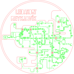
After finishing the map of downtown Reykjavík, the next idea came to me on the way home while I accidentally took the wrong bus and ended up having to switch buses a couple of times to get to my destination. Luckily the buses had wifi so I could quite easily check on my phone which ones would take me home, but it got me wonderin what I'd do if my batery had run out or something else, so I came up with the idea of making a bus map.
I liked the plexi inlay technique, so I wanted to include some of it in this project too. Also, the round shape of the map looked nice, so I went with it again. The map wasn't too easy to find - I had to dig around the old straeto website, which luckily still had and old map file, and it was even a vector pdf so I was really pleased to find it.
I spent some time tweaking te map, simplifying it, deleting the landmarks and names of the stops. At first I had only thought about cutting out the sea and engraving the rest, but I decided to also cut out the s-signs of the larger bus stations. I had learned to use the color mapping settings the day before, so this was a good opportunity to put it into use. Most of the time went into tidying the map, I wasn't very familiar with Inkscape yet so now I would know how to get it done faster, but it was a good learning experience.
